


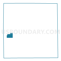
Voting District 0777930000002, Kalamazoo County, Michigan
About
Outline

Summary
| Unique Area Identifier | 597163 |
| Name | Voting District 0777930000002 |
| County | Kalamazoo County |
| State | Michigan |
| Area (square miles) | 4.14 |
| Land Area (square miles) | 3.45 |
| Water Area (square miles) | 0.69 |
| % of Land Area | 83.39 |
| % of Water Area | 16.61 |
| Latitude of the Internal Point | 42.21346120 |
| Longtitude of the Internal Point | -85.71053440 |
Maps


Graphs
Select a template below for downloading or customizing gragh for Voting District 0777930000002, Kalamazoo County, Michigan


Neighbors
Neighoring Voting District (by Name) Neighboring Voting District on the Map
- Voting District 0777930000001, Kalamazoo County, MI
- Voting District 0777930000003, Kalamazoo County, MI
- Voting District 0777930000005, Kalamazoo County, MI
- Voting District 0777930000006, Kalamazoo County, MI
Top 10 Neighboring County Subdivision (by Population) Neighboring County Subdivision on the Map
Top 10 Neighboring Unified School District (by Population) Neighboring Unified School District on the Map
- Kalamazoo Public School District, MI (107,907)
- Portage Public Schools, MI (51,511)
- Mattawan Consolidated School, MI (18,006)